
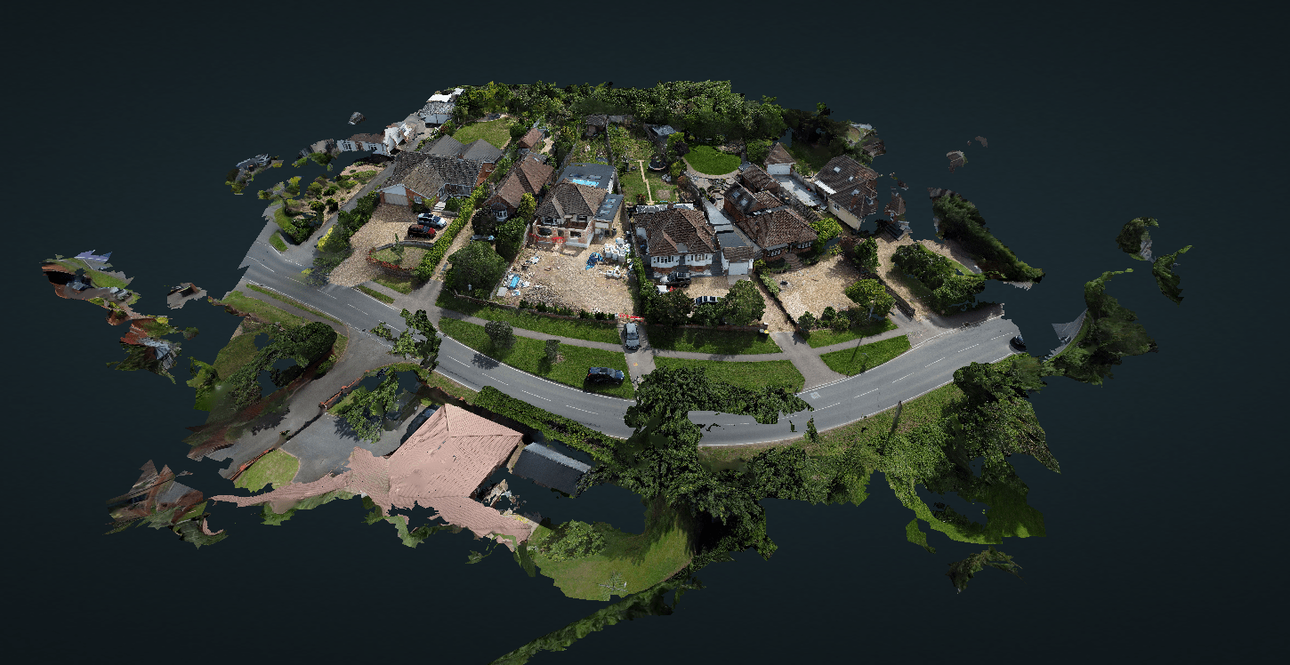
If you’re planning an extension, a loft conversion, a new driveway or a full development, everyone involved needs the same thing first: an accurate picture of what’s already there. Traditionally that means tape measures, ladders, repeat site visits and a lot of back-and-forth between homeowner, architect and builder.
Drone mapping offers a faster way to get there. In a single site visit, we can capture your entire property from above and turn it into an interactive 3D model you can explore, measure and share from any web browser.
Here’s how drone mapping works, what you get, and who it’s useful for across Bedford, Bedfordshire and the surrounding counties.
What is drone mapping?
Drone mapping (also known as drone photogrammetry) uses hundreds of overlapping aerial photographs, taken along a carefully planned flight path. Specialist software then stitches those images together into an accurate digital version of your property or site.
Unlike a standard aerial photo, which shows one view from one angle, a drone map is a complete digital record. You can rotate it, zoom into specific areas and take measurements directly from it, without ever setting foot on site.
What’s included in a drone mapping project?
Every drone mapping project from Wigram Drones includes:
- Interactive 3D model: a realistic, rotatable model of your property or site that you can view from virtually any angle.
- High resolution orthomosaic: a detailed top-down aerial map created from hundreds of photos. Think of it as a sharp, up-to-date satellite image of just your site.
- Surface model: a colour-coded elevation map showing changes in height across the site, making it easy to understand terrain, slopes and roof heights.
- Online viewing portal: everything is accessible through a modern web browser, with no software to install, and can be shared with a simple link.
- Built-in measurement tools: measure distances, areas, roof pitches, angles and building dimensions directly within the model.
Who is drone mapping for?
Homeowners planning extensions and renovations
The early stages of an extension, loft conversion or garden redesign are full of questions. How big is the plot? What’s the pitch of the existing roof? How far is the boundary from the back of the house? A 3D model answers these from your sofa, and you can share it with your architect before their first visit.
We recently completed a residential drone mapping project in Bedfordshire for exactly this reason, giving the homeowner a complete digital record to support their future planning and development work.
Architects and designers
An accurate model of existing conditions, including neighbouring buildings, ground levels and roof lines, helps you design with confidence and cuts down on repeat site visits. Clients can also explore the model themselves, which makes design conversations much easier.
Builders and roofers
Roof areas and pitches can be measured directly from the model, helping you estimate materials and price jobs more accurately without climbing a ladder. Combined with our drone roof inspections, you get both the measurements and close-up imagery of the roof’s condition.
Construction sites and developers
Regular mapping flights create a visual timeline of your project. Comparing orthomosaics from different dates is a simple way to track progress, keep stakeholders updated and maintain clear records. Find out more about our construction site inspections.
Commercial property and landowners
Warehouses, industrial units, farmland and large estates can be documented quickly and safely. For large commercial roofs, like the warehouses we’ve recently inspected in Milton Keynes and Northamptonshire, a 3D model makes it easy to plan maintenance across the whole building.
The benefits of drone mapping over traditional methods
- Faster: the whole property is captured in a single visit, rather than hours of manual measuring.
- Safer: no ladders, scaffolding or working at height.
- Easy to share: one link gives your architect, builder, surveyor or planning consultant the same view of the site.
- A permanent record: your model captures the property exactly as it was on the day, which is useful for before-and-after comparisons once work is complete.
- Fewer site visits: many questions can be answered from the model rather than by sending someone back out.
It’s worth being clear about where drone mapping fits. It’s an excellent tool for planning, estimating and documentation. If your project formally requires a measured building survey or topographical survey from a chartered surveyor, our models work alongside that survey rather than replacing it. We’re always happy to talk through what your project actually needs.
How a drone mapping project works
- Get in touch: send us your address and a few details about your project. WhatsApp is the quickest way, and you can include photos or plans.
- Flight planning: we check airspace restrictions and permissions, then plan an automated flight path to capture the whole property.
- Capture: on site, the drone flies a set pattern to take hundreds of overlapping photos, plus angled shots to pick up walls and roof detail.
- Processing: our software builds your 3D model, orthomosaic and surface model.
- Delivery: you receive access to your online model, ready to explore, measure and share.
Why now is a great time to map your property
Many homeowners use the autumn and winter months to plan building work for the spring and summer. With designs, quotes and planning applications all taking time, having an accurate model of your property early on helps keep everything moving.
Winter also has a practical advantage: with the leaves off the trees, roofs, gutters and ground levels are often far easier to see from the air than they are in summer.
Drone mapping across Bedfordshire and beyond
Wigram Drones is based at Wrest Park in Silsoe, and we provide drone mapping throughout Bedford and Bedfordshire, as well as Milton Keynes, Northamptonshire, Hertfordshire, Buckinghamshire, Cambridgeshire and London. We’re also happy to travel further across the UK for larger projects.
Drone mapping FAQs
Can I share the 3D model with my architect or builder?
Yes. Your model is hosted online and can be opened in any modern web browser, so you can simply send them the link.
Can I take measurements myself?
Yes. The model includes built-in tools for measuring distances, areas, roof pitches and angles.
Does drone mapping replace a measured survey?
Not where a formal measured or topographical survey is required. Drone mapping is ideal for planning, estimating and documenting a property, and it works well alongside a surveyor’s work.
Is it legal to fly a drone over my property?
Yes, when it’s done properly. Wigram Drones is registered with the CAA, fully insured for commercial operations and flown by an A2 CofC certified pilot. Every flight is planned around local airspace restrictions.
What weather do you need?
Dry and reasonably calm conditions give the best results. If rain or strong winds are forecast, we’ll rearrange the flight for a better day.
Get a free drone mapping quote
Whether you’re planning an extension, managing a construction project or simply want an accurate digital record of your property, we’d love to help.
The fastest way to get a quote is to message us on WhatsApp or call 07486 035711. You can also fill in our contact form and we’ll get back to you as soon as possible.